Introduction
Students will apply various vector geoprocessing tools discussed in lecture and practiced in assignments to determine the suitable habitat for Bears in Marquette County, MI. Direction is not given as to what vector geoprocessing tools should be used for each task. These decisions are left up to the student to determine.
Methods
Task One
Determine the total number of bears located within each land cover type.
Provided data: bear_locations_geo.xls and landcover feature class (minor_type)
Figure 1: Start by finding the excel spreadsheet in the catalog window. Right class the desired sheet, and than click Create Feature Class > From XY Table.... The Create Feature Class From XY Table window appears. Here the X, Y, and Z fields, coordinate system, and output location an be chosen. Clicking OK will create bear_locations.shp.
Figure 2: Once the bear_locations,shp has been created it can be spatially joined to the landcover feature class symbolized by minor_type. Right click bear_locations in the Table of Contents and click Joins and Relates > Join.... The Join Data window appears and landcover is chosen in the 1. dropdown menu and the bubble next to "it falls inside" is filled. Clicking OK will create a new point feature class with all the attributes of both bear_locations.shp and landcover.
Figure 3: Opening the attribute table for the newly created feature class, right clicking the minor_type field, and choosing Summerize... will open the Summarize window. Clicking Ok in the Summarize window will create a table summarizing the number of records (bears) in each minor type of landcover. This is that table.
Task Two
Determine the number of bears within 500 meters of a stream.
New Provided data: streams feature class
Figure 4: Use Select by Location. Click Selection in the main toolbar and than Select by Location. The target layer is bear_locations, source layer is streams, and spatial selection method is "are within a distance of the source layer feature." Set the distance to 500 meters and click OK. The number of bears within 500 meters of a stream will be highlighted.
Task Three
Find the suitable area for bear habitats based on the critiera from the first two tasks. Criteria: area must be within the 3 landcover types with the most bears and be within 500 meters of a stream.
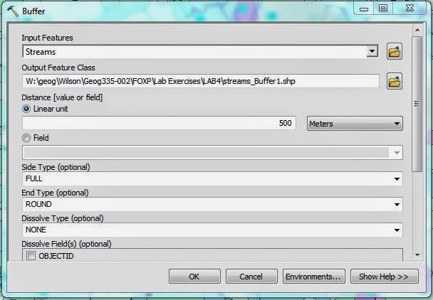
Figure 5: To get the area within 500 meters of a stream, preform a buffer on streams. Open the ArcToolbox and navigate to Analysis Tools > Proximity > Buffer. The Buffer window will appear. The input features will be the streams feature class and distance will be set to 500 meters.
Figure 6: Next select by attributes on landcover by the three desired landcover types. Once they are selected an intersect can be preformed to determine the area that coincides with both the landcover and the streams buffer. Open the ArcToolbox and navigate to Analysis Tools > Overlay > Intersect. The input feature is chosen twice, streams and landcover are chosen (the selection of landcover is automatically used not the entire feature class). Clicking OK will produce the suitable habitat.
The dissolve tool can be used to remove the internal boundaries, resulting from the buffer and intersect tool operations, in the feature class of suitable habitats. Open the ArcToolbox and navigate to Data Management Tools > Generalization > Dissolve. Input features is the suitable habitat feature class. Clicking OK will make the suitable habitat feature class look more visually pleasing.
Task Four
Determine the area of suitable habitat that coincides with land owned by the DNR. The DNR wishes to use this land in part of their new bear management plan.
New provided data: dnr_mgmt feature class, study area feature class
Figure 7: To prepare the dnr_mgmt feature class, clip it by the study area, which is smaller than the extent of the dnr_mgmt feature class, and dissolve the internal boundaries in the data. Clip can be found in the ArcToolbox > Analysis Tools > Extract > Clip. Input features should be dnr_mgmt and clip features should be study area. Use the same process after figure 6 to dissolve the data.
Next use the intersect tool (location detailed under Figure 6) on the clipped, dissolved dnr_mgmt feature class and the suitable habitat feature class created in Figure 6. This will give the land that coincides with each feature class and can be given to the DNR.
Task Five
Exclude areas in the bear habitat feature class that are within 5 kilometers of urban or built-up areas.
New Provided data: landcover feature class (major_type)
Select by attributes the urban and built-up areas from the landcover feature class under major_type. Preform a buffer (detailed in Figure 5) on the selection of landcover.
Figure 8: After the urban areas are selected. Use the erase tool located in the ArcToolbox > Analysis Tools > Overlay > Erase. The input features should be suitable habitat feature class and the erase features should be the urban area buffer. This will erase the area of the buffer from the suitable habitat feature class.
Results
Figure 9: The final result. A map of suitable bear habitats that fit all the criteria, the area suitable for the DNR bear management plan, and all bear locations.


No comments:
Post a Comment